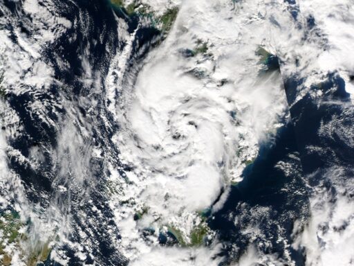

Federal forecasters are telling coastal residents to expect a quieter Atlantic this year, with fewer tropical storms and hurricanes than average. The shift comes as a strengthening El Niño pattern in the Pacific tilts the atmosphere against storm formation over the Atlantic, even as ocean waters there remain unusually warm.
A below-normal season does not remove the risk of a destructive landfall, but it changes the odds and the way emergency managers, insurers, and coastal communities think about the next several months.
How NOAA’s new outlook resets expectations for the 2026 season
The National Oceanic and Atmospheric Administration has issued a seasonal outlook that calls for a below-normal Atlantic hurricane season, projecting a reduced number of named storms and hurricanes compared with the long-term average. In its official forecast, NOAA expects fewer systems to form in the Atlantic basin, which includes the Caribbean Sea and Gulf of Mexico, as El Niño gains strength in the Pacific.
Forecasters base this outlook on a combination of ocean temperatures, atmospheric patterns, and climate signals. The agency’s seasonal team weighs decades of historical data, current sea surface temperature anomalies, and model guidance to estimate how many storms are likely to develop and how many could reach hurricane or major hurricane strength. That process has now yielded a clear message: activity should be suppressed relative to the busy seasons that have dominated much of the past decade.
Local and regional meteorologists are already translating that national forecast into more specific expectations for their audiences. In Florida, television forecasters have highlighted NOAA’s call for fewer storms and emphasized that the agency still urges residents to prepare as if at least one hurricane will threaten the state. Coverage of the forecast on a central Florida station explained that the official outlook points to below-average storm counts but does not attempt to predict individual landfalls.
National outlets have framed the forecast as a rare bit of relatively good news for coastal communities that have endured a series of intense seasons. One summary of the seasonal guidance noted that the Atlantic is expected to produce fewer storms than the recent norm, even as climate change continues to load the dice toward heavier rainfall and stronger winds when storms do form. That coverage of the below-average season stressed that the outlook is probabilistic, not a guarantee.
El Niño’s growing influence and why it matters this year
The key change behind NOAA’s new forecast is the development of a strong El Niño event in the equatorial Pacific. During El Niño, warmer-than-normal water in the central and eastern Pacific alters atmospheric circulation, which in turn increases wind shear over the tropical Atlantic. Stronger upper-level winds tend to disrupt developing storms, tilting and tearing apart their cores before they can organize into hurricanes.
Forecasters in Florida have highlighted how this pattern is already shaping expectations. A detailed analysis from a Florida newspaper explained that the emerging El Niño has prompted experts to trim their storm counts even further, with one local meteorologist describing how increasing shear should tamp down on systems that try to form near the Caribbean and western Atlantic. That report noted that, thanks to El Niño, even fewer storms are now expected than in early preseason outlooks.
In North Carolina, where residents still remember the impacts of hurricanes like Florence, regional coverage has focused on how a so-called “super El Niño” could reshape risk along the East Coast. A detailed piece on the 2026 outlook explained that a powerful El Niño tends to steer the jet stream in a way that favors more frontal systems and fewer landfalling hurricanes in the Carolinas, although the state remains vulnerable to any storm that manages to slip through. The article on El Niño’s impact made clear that even during quiet seasons, one well-aimed storm can define the year.
Despite the suppressing effect of El Niño, the Atlantic itself remains warmer than the long-term average, especially in the main development region between Africa and the Caribbean. Warm water provides fuel for any system that can overcome the hostile winds overhead. Some meteorologists have pointed out that this tug-of-war between warm Atlantic waters and Pacific-driven shear adds uncertainty to the forecast. If El Niño underperforms or fades more quickly than expected, storm numbers could end up closer to average.
Emergency managers are watching these signals closely. For them, a below-normal forecast changes planning emphasis but not the need for readiness. Many coastal counties still assume they will have to manage at least one evacuation or major storm response, regardless of the seasonal odds.
Why a quieter forecast still carries high stakes for coastal communities
For residents from Texas to the Outer Banks, a below-normal outlook can be both a relief and a risk. History shows that some of the most damaging hurricanes on record have struck in years that were not especially active overall. One storm hitting a densely populated area can outweigh an entire season of weak systems that stay over open water.
Local coverage in Florida has tried to balance cautious optimism with a reminder that preparation timelines do not change. Television meteorologists there have stressed that households should still check evacuation routes, review insurance coverage, and refresh supply kits, even though NOAA expects fewer storms. The regional forecast segment emphasized that El Niño can reduce storm counts but does not shield any single city from a direct hit.
National reporting on the forecast has also pointed to the broader climate context. While El Niño may suppress the number of storms this year, long-term warming of the oceans is associated with higher rainfall rates and, in some cases, stronger peak winds in the storms that do form. The analysis of the seasonal outlook noted that coastal infrastructure, from housing to power grids, is still catching up to the damage potential of slow-moving, rain-heavy systems.
For inland communities, the forecast matters in different ways. Fewer landfalling storms can mean less risk of catastrophic river flooding in states like North Carolina, Georgia, and Tennessee. Yet forecasters there are warning that residents should not tune out just because the overall storm count is expected to be lower. The discussion of North Carolina’s risk highlighted how remnants of tropical systems can still trigger landslides and flash floods in mountain communities far from the coast.
Insurance markets are another place where the outlook carries weight. A quieter season can ease pressure on reinsurance costs and help stabilize premiums in hurricane-prone states, especially Florida and Louisiana, where insurers have struggled after a run of costly years. Some state regulators have indicated that a calm season would give them breathing room to rebuild catastrophe reserves, though they caution that one major landfall would still generate large claims.
How forecasters, officials, and residents are preparing for what comes next
With the season underway, the focus now shifts from seasonal probabilities to individual storms. NOAA’s outlook will be updated if El Niño or Atlantic conditions change significantly, but day-to-day forecasting will hinge on satellite observations, aircraft reconnaissance, and short-range models that track each disturbance as it forms.
Local meteorologists are using the below-normal forecast as a teaching moment. In Florida, broadcast segments have walked viewers through how El Niño alters wind patterns and why that matters for storm structure, while still returning to the message that preparation should not depend on seasonal odds. A Jacksonville-focused analysis of the Atlantic forecast urged residents to treat every season as if it will bring at least one close call.
Emergency management agencies across the Southeast are also adjusting their communication strategies. Some are leaning into the relative good news to encourage residents to take preparedness steps while anxiety is lower, arguing that it is easier to talk about evacuation plans and supply kits when people do not feel overwhelmed. Others worry that the phrase “below-normal” can breed complacency, so they are pairing the forecast with reminders of past destructive storms that struck in otherwise quiet years.