
A broad disturbance in the eastern Pacific has organized enough thunderstorms for forecasters to assign it a 40 percent chance of developing into a named tropical storm this weekend. The system remains in its formative stages, but its track and timing place it in a busy ocean corridor that often seeds early-season cyclones with impacts that can ripple into Mexico, Central America, and the U.S. Southwest.
Although the odds of development remain below even, a 40 percent probability is high enough to warrant closer monitoring from coastal communities, shipping interests, and anyone planning travel along the Pacific side of North and Central America.
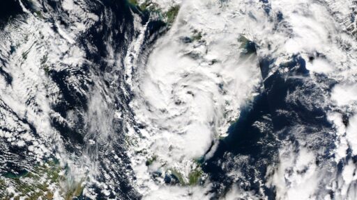
How the Pacific disturbance evolved into a 40 percent development risk
The disturbance is a sprawling area of low pressure embedded in a zone of enhanced thunderstorms over the warm eastern Pacific. Forecasters raised its development odds to 40 percent as satellite imagery showed more persistent convection near the center and hints of a more defined low-level circulation. That threshold marks a meaningful shift from a loosely organized cluster of storms to a system that could consolidate into a tropical depression if conditions cooperate.
In the eastern Pacific, early-season systems often begin as broad gyres that spin for days before tightening into a recognizable cyclone. The current disturbance fits that pattern, with scattered thunderstorm bursts gradually coalescing into larger, more sustained clusters. As upper-level winds relaxed slightly and sea-surface temperatures stayed supportive, forecast models began to converge on a scenario where the low could strengthen over the next several days. Those trends prompted the updated outlook that now gives the system a 40 percent chance of becoming the next named storm by this weekend.
The probability does not guarantee development, but it signals that the disturbance has cleared several early hurdles. It has maintained a coherent low-level center rather than being ripped apart by wind shear. It has tapped into a moist environment that supports deep thunderstorms instead of shallow, short-lived showers. It is also positioned over waters warm enough to fuel further organization. Each of those ingredients can still change, yet together they justify an outlook that is no longer dismissive of tropical formation.
Forecasters are also watching how numerical models handle the system. When a disturbance appears consistently across several model runs, and when separate modeling suites begin to agree on its potential, confidence in development rises. In this case, multiple guidance packages have hinted that the low will track over a favorable pocket of ocean and may slow down slightly, a combination that often precedes intensification.
Why a 40 percent development chance carries real-world stakes
A 40 percent probability might sound modest, but for coastal residents and emergency planners it represents a meaningful signal. In tropical outlooks, that middle tier of odds often marks the point when a system moves from background noise to a feature that can affect decisions about shipping routes, port operations, and coastal readiness. Even if the disturbance never earns a name, its moisture and wind field can still bring heavy rain, rough seas, and rip currents to nearby shores.
The eastern Pacific basin frequently produces storms that track parallel to the Mexican coastline. Some stay offshore yet generate large swells and dangerous surf along beaches from Chiapas to Baja California. Others bend closer to land, bringing periods of intense rain that can trigger flash flooding and landslides in mountainous terrain. When forecasters highlight a disturbance with a 40 percent chance of development, communities in those zones begin to weigh the possibility of such hazards, especially if the projected path hugs the coastline.
There is also a broader seasonal context. Early or active disturbances in the eastern Pacific can signal an atmosphere primed for more frequent storms in the weeks ahead. Warm sea-surface temperatures and favorable wind patterns that support this system may persist and influence subsequent waves that roll off Central America. For sectors like agriculture, tourism, and energy, that backdrop shapes planning far beyond a single storm.
Even without a formal tropical cyclone, the disturbance can act as a moisture pipeline. Deep tropical humidity transported inland can enhance daily thunderstorms over Mexico’s interior and, in some patterns, feed into monsoon surges that reach the deserts of Arizona, New Mexico, and southern California. Residents who have experienced past events know that such surges can quickly transform dry washes into fast-moving streams and overwhelm urban drainage in cities like Phoenix and Tucson.
From a forecasting standpoint, the 40 percent figure is also a communication tool. It reflects not only the physical state of the disturbance but also the level of uncertainty. By assigning a specific probability, meteorologists convey that the system is neither a long shot nor a near certainty. That calibrated message helps avoid both complacency and overreaction, encouraging coastal interests to monitor updates without assuming a worst-case scenario.
Potential tracks, impacts, and signals to watch through the weekend
Attention now shifts to how the disturbance behaves over the next several days. Key questions revolve around its track relative to the Mexican coast, the strength of upper-level winds, and the timing of any consolidation of its low-level center. Small shifts in those factors can mean the difference between a disorganized cluster of storms and a named tropical cyclone.
Should the system remain offshore over very warm water, it will have a better chance to organize into a tropical depression and possibly a tropical storm. In that scenario, the primary impacts for land could be large swells, strong rip currents, and periods of heavy rain along segments of the Pacific coast. Mariners would face building seas and gusty squalls along the storm’s outer bands. If the disturbance tracks closer to land or interacts with rugged terrain, however, its circulation could stay elongated and struggle to tighten, limiting its ability to strengthen.
Several atmospheric cues will help forecasters refine the outlook. A decrease in vertical wind shear would favor more robust thunderstorm growth near the center, a classic sign that a system is on the cusp of classification. A more symmetric cloud shield on satellite imagery, with cold cloud tops wrapping around a defined core, would also point toward imminent development. Conversely, if convection remains lopsided or repeatedly collapses, the odds of formation may trend downward from the current 40 percent assessment.
For residents and travelers, practical steps at this stage center on awareness rather than action. Coastal communities that routinely face Pacific storms often use these early outlooks to review communication plans and verify that drainage systems, emergency shelters, and supply chains are ready for a potential escalation later in the season. Tour operators and cruise lines may track the disturbance closely to adjust itineraries if forecast confidence in a particular path increases.
Through the weekend, the most useful signals for the public will be updated tropical weather outlooks, satellite loops that show how the disturbance is organizing, and any new model consensus on its track. If the system earns a name, that change will trigger more detailed advisories, including predicted wind speeds, rainfall totals, and surf impacts. If it fails to consolidate, the disturbance could still deliver bouts of heavy rain and rough seas, but with a lower risk of intense, organized winds.
Either way, the 40 percent development chance has already served its purpose by flagging a system that deserves attention. In a basin where conditions can shift quickly, early awareness often makes the difference between a manageable event and a scramble to respond. As the disturbance moves through its most favorable window for strengthening, the next few forecast cycles will clarify whether it becomes the next named storm or remains a reminder of how quickly the Pacific can stir.