
High-resolution satellite imagery has revealed hundreds of enigmatic stone monuments scattered across the desert of northeast Africa, reshaping what researchers thought they knew about one of the driest regions on Earth. The newly mapped structures, many arranged in circles and alignments, point to a long-lived ritual landscape created by communities that once thrived where today there is only sand and rock.
The discovery suggests that the eastern Sahara once hosted a dense network of ceremonial sites linked by movement, memory, and perhaps trade, adding a new chapter to the story of how people adapted to extreme environments over thousands of years.
New satellite views of a hidden ritual landscape
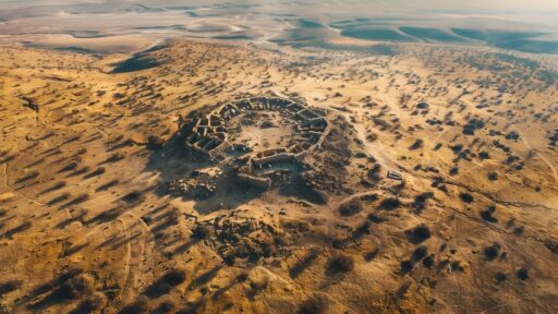
Archaeologists working with commercial and open-access satellite data have identified at least 280 ancient stone circles in the desert of eastern Sudan, along the margins of the Nile and its seasonal tributaries. The features are subtle on the ground, often built from low stones that barely rise above the surrounding surface, yet they stand out clearly once viewed from orbit as crisp rings and linear patterns etched into pale sand.
Many of the circles appear in clusters, with some groups containing dozens of individual monuments that range from a few meters across to much larger compounds. Researchers describe cairns, ring-shaped platforms, and radial layouts that suggest deliberate planning rather than random piles of stones. The patterning indicates that builders reused certain spots over generations, returning to the same ridges, terraces, and ancient shorelines to construct new features alongside older ones.
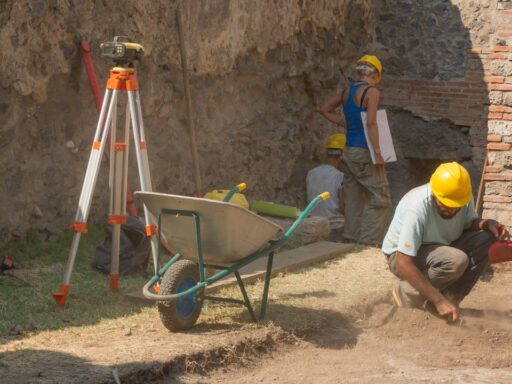
Initial field checks at a subset of sites confirm that the structures are human-made and premodern, with surface finds that include pottery fragments and worked stone. Although systematic excavation has only begun, the architecture resembles funerary and ceremonial monuments known from other parts of the Sahara, pointing to a likely ritual function. Some circles have central mounds or standing stones that could have served as focal points for gatherings or commemorations.
The density of features surprised researchers, who had previously documented isolated stone monuments in Sudan but not such an extensive complex. The satellite survey suggests that what had seemed like scattered traces are actually parts of a much larger cultural system that extended across plateaus, wadis, and former lake basins.
How digital mapping changed the picture of Sudan’s desert past
The breakthrough reflects a broader shift in archaeological practice, with analysts now combing through high-resolution imagery before they ever set foot in the field. In this case, the team systematically scanned large tracts of eastern Sudan, using visual inspection and basic image enhancement to pick out circular and linear anomalies that did not match natural geology. The approach allowed them to flag potential sites across thousands of square kilometers in a fraction of the time a ground survey would require.
After the satellite candidates were mapped, researchers overlaid them on topographic data and older aerial photographs to see how the monuments related to ancient watercourses and landforms. Many circles sit on slight elevations overlooking dry riverbeds or on promontories that would have offered wide views of the surrounding landscape. This spatial pattern supports the idea that monument builders were responding to both practical and symbolic cues, choosing spots that were visible, accessible, and perhaps associated with seasonal water or pasture.
Field visits have begun to ground-truth a sample of the mapped features, confirming that the satellite signatures match low stone constructions on the surface. At several locations, archaeologists documented intact rings, cairns, and associated small structures that align closely with the imagery. The combination of remote sensing and targeted on-site work gives the project confidence that many of the still unvisited circles represent similar monuments.
The published results describe at least 280 stone circles and related structures, but the authors emphasize that this is likely a minimum figure. Sand cover, erosion, and the limits of current imagery mean that smaller or more degraded monuments may remain invisible from space. Even so, the mapped dataset already transforms the archaeological map of eastern Sudan, highlighting a corridor of past activity that had received relatively little systematic attention.
The new survey builds on earlier work that used satellite tools to locate burial tumuli, prehistoric settlement mounds, and rock art sites across the Sahara. What sets this project apart is the sheer concentration of ritual features in a region long regarded as marginal, suggesting that the desert margins of northeast Africa were more socially and spiritually active than previously assumed.
Why a lost desert culture matters for climate and migration history
The newly documented monuments offer more than an inventory of ancient structures. They open a window onto how people responded to major environmental shifts at the edge of the Sahara. Climatic records show that northeast Africa experienced a long-term drying trend after the African Humid Period, when lakes, wetlands, and grasslands were far more extensive than today. As rainfall declined, communities would have faced shrinking resources and changing migration routes.
The location of the stone circles near fossil river channels and former lake margins hints that their builders were navigating this transition. Some monuments may date to a time when the area still supported seasonal grazing and water, while others could belong to later phases when the environment had already become harsher. If so, the landscape of circles preserves a layered record of how groups marked territory, honored ancestors, or coordinated movement as conditions changed.
Understanding that sequence will require detailed dating, including radiocarbon analysis of organic material from burials or occupation layers beneath or within the structures. The first field campaigns have already collected samples and documented pottery styles that can be compared with better-known sequences along the Nile Valley. Those comparisons may reveal whether the monument builders were closely tied to Nile-based societies or represented more independent desert communities that interacted with riverine neighbors only intermittently.
The finds also speak to debates over how mobile pastoralists used monumental architecture. In many parts of the Sahara, researchers have linked stone circles, cairns, and alignments to groups who moved seasonally with herds but still invested labor in building durable landmarks. The Sudanese complexes fit that pattern, suggesting that mobility and monumentality often went together rather than being opposing ways of life. The circles could have served as meeting points, burial grounds, or markers of group identity along seasonal routes.
For modern audiences, the discovery challenges stereotypes of deserts as empty or timeless. The mapped sites show that what appears today as a barren expanse was once crisscrossed by paths, stories, and rituals. They also highlight how quickly human traces can fade from view when societies move on or conditions deteriorate, only to be rediscovered centuries later through new technologies.
Next steps for decoding Sudan’s stone circles
The satellite survey is only the first stage of a longer research program. Archaeologists now face the task of prioritizing which of the hundreds of mapped sites to investigate in detail. Factors such as accessibility, risk from modern development, and representativeness of different monument types will shape that triage. Some of the most promising clusters may become focal points for multi-season excavations that combine archaeology, geology, and paleoenvironmental studies.
Future work will likely include geophysical prospection, such as ground-penetrating radar and magnetometry, to look beneath the surface without disturbing fragile structures. These techniques can reveal buried chambers, post holes, or earlier construction phases inside and around the visible circles. Combined with careful excavation, they should clarify whether the monuments were primarily funerary, commemorative, or used for other forms of gathering.
Researchers also plan to integrate the stone circle data with broader regional models of past climate and hydrology. By comparing monument locations with reconstructions of rainfall patterns, groundwater availability, and vegetation, they hope to trace how settlement and ritual landscapes shifted over time. That work may show, for example, whether people abandoned certain corridors as aridity intensified or instead invested more heavily in monuments as a response to environmental stress.