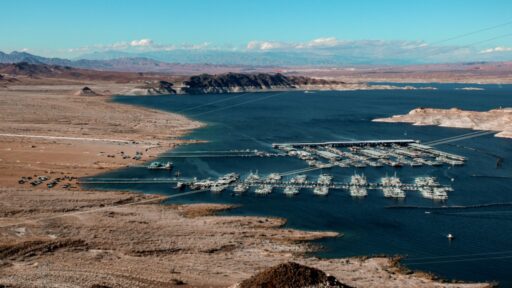
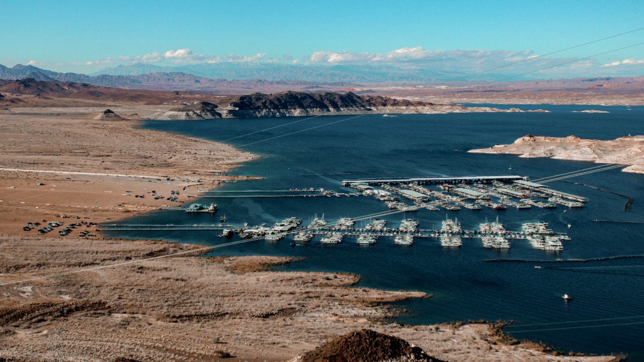

Lake Mead is sinking toward one of the lowest levels ever recorded, renewing fears about the Colorado River system and the millions of people who depend on it. The reservoir, held back by Hoover Dam on the Nevada-Arizona border, has been dropping through the summer as dry conditions, weak runoff, high heat, and long-term overuse continue to strain the river.
The latest daily data from the U.S. Bureau of Reclamation’s Lower Colorado River Operations report showed Lake Mead at 1,043.52 feet above sea level on July 6, 2026. That placed it only a few feet above the record-low elevation reached in July 2022, when the lake fell close to 1,040 feet.
Reclamation’s end-of-month elevation table also shows how quickly the reservoir has been declining this year. Lake Mead ended January 2026 at 1,065.37 feet, February at 1,066.14 feet, March at 1,062.05 feet, April at 1,056.32 feet, May at 1,050.00 feet, and June at 1,044.58 feet, according to the agency’s Lake Mead elevation records.
That trend is the reason water watchers are worried. The lake is not simply low. It is moving back toward the historic bottom reached during the worst years of the recent drought.
Why the July Level Matters
Lake Mead’s all-time modern low came in July 2022, when the reservoir dropped to around 1,040 feet above sea level. That record became a symbol of the Colorado River crisis because it exposed more of the lake’s white “bathtub ring,” stranded boat ramps, threatened hydropower, and forced deeper water cuts across the Southwest.
This month’s decline is alarming because Lake Mead is again approaching that same zone. Even a few feet matter at this stage because the lake’s shoreline, storage volume, boat access, power operations, and water-delivery calculations are all tied to elevation.
A reservoir can look enormous from above and still be dangerously depleted. Lake Mead has steep banks in many areas, so the visual scale can hide how much usable water has already disappeared. What matters for water managers is not only the surface area, but the elevation, storage volume, and how much water can be released through Hoover Dam.
What Is Driving the Drop
Lake Mead is fed by the Colorado River system, and the river depends heavily on snowpack in the Rocky Mountains and upper basin. When winter snow is poor, spring runoff is weak. When spring is hot, more snow evaporates, melts early, or soaks into dry soils before it reaches rivers and reservoirs.
This year, the broader Colorado River system has been hit by poor snowpack and intense heat. The Guardian reported that Lake Powell, the key upstream reservoir from Lake Mead, barely recovered during spring runoff and stood at about 22% of capacity in early July 2026. Experts warned that the system is “careening toward a breaking point” as the West warms and dries.
Lake Mead’s decline is tied to the same problem. The river is being asked to supply cities, farms, tribes, ecosystems, hydropower, and international treaty obligations with less water than the old rules assumed would be available.
Why Lake Powell Matters to Lake Mead
Lake Powell sits upstream on the Colorado River behind Glen Canyon Dam. Lake Mead sits downstream behind Hoover Dam. Together, the two reservoirs act as the central storage system for the Colorado River Basin.
When Lake Powell is low, it limits flexibility for releases to Lake Mead. When Lake Mead is low, it triggers water-supply cuts for the Lower Basin states and Mexico. If both reservoirs are low at the same time, the entire system becomes harder to manage.
That is the situation now. Lake Powell’s weak recovery this year means it cannot easily rescue Lake Mead without creating its own risks. Water managers must balance two depleted reservoirs rather than relying on one full reservoir to support the other.
The Colorado River Supports Tens of Millions
The Colorado River supplies water to roughly 40 million people across the Southwest and Mexico. It supports cities including Las Vegas, Phoenix, Tucson, Los Angeles, San Diego, Denver, and many smaller communities. It also irrigates major agricultural regions that grow vegetables, hay, fruit, and other crops.
The river is shared by seven U.S. basin states: Arizona, California, Colorado, Nevada, New Mexico, Utah, and Wyoming. Mexico also receives water under treaty agreements. Dozens of tribal nations have rights and interests in the river, many of which have historically been underdeveloped or excluded from major planning decisions.
Lake Mead’s decline is therefore not just a Nevada or Arizona problem. It is a regional water-security problem.
Why the Shortage Rules Matter
When Lake Mead drops below certain elevations, shortage rules require reductions in water deliveries. The Bureau of Reclamation announced that Lake Mead would remain in a Level 1 Shortage Condition for 2026, with required reductions for Arizona, Nevada, and Mexico under existing operating rules.
In its 2026 operating conditions announcement, Reclamation said Arizona would contribute 512,000 acre-feet, Nevada 21,000 acre-feet, and Mexico 80,000 acre-feet under shortage and drought-contingency rules. Those reductions are meant to slow reservoir decline, but they have not restored the system to comfortable levels.
The deeper Lake Mead falls, the more pressure grows for additional conservation, new rules, and difficult water-sharing decisions.
Why 2026 Is a Critical Year
The current Colorado River operating guidelines are set to expire at the end of 2026. That makes this year especially important. The basin states, tribes, Mexico, federal officials, cities, farmers, and water agencies are all trying to shape the next long-term management system.
The problem is that the river’s legal framework was built around assumptions from a wetter period. For more than two decades, the river has produced less water than users were promised on paper. Climate change, higher temperatures, drier soils, and persistent overuse have made the gap harder to ignore.
Lake Mead’s drop this month is not only a water-level update. It is a warning signal arriving during a major policy transition.
Why “Drought” Is Not the Whole Story
Drought is part of the problem, but the Colorado River crisis is bigger than drought alone. A drought suggests a temporary dry period followed by recovery. The Southwest is facing something more structural: aridification, or a long-term drying trend driven by higher temperatures and reduced runoff.
Warmer air increases evaporation from reservoirs, soils, and vegetation. It also reduces the amount of snowmelt that reaches rivers. Even when precipitation is near normal, hotter conditions can leave less usable water.
That is why experts often say the Colorado River is not only suffering from a lack of rain and snow. It is suffering from a warmer climate that squeezes more water out of the system before it reaches reservoirs.
Why Farmers Are Central to the Debate
Agriculture uses the largest share of Colorado River water. That does not mean farmers are the only cause of the crisis, but it does mean no serious solution can ignore farming.
The river supports crops in Arizona, California’s Imperial Valley, and other major agricultural areas. Some crops feed people directly, while others support livestock. Water reductions can affect farm income, rural economies, food supply chains, land values, and local jobs.
Cities have made major conservation gains, especially in places like Las Vegas, which recycles nearly all indoor water and has paid residents to remove grass. But urban conservation alone cannot solve the entire basin-wide imbalance. The hardest negotiations involve who uses how much water, what crops are grown, who gets paid to conserve, and how permanent reductions should be.
Why Las Vegas Is Watching Closely
Las Vegas is often associated with Lake Mead because the city sits near the reservoir and depends on the Colorado River for most of its water. But southern Nevada has also become one of the most aggressive urban water-conservation examples in the country.
The region has removed large amounts of decorative grass, restricted certain outdoor water uses, recycled indoor water back to Lake Mead, and built deep intake infrastructure to keep drawing water even as the lake falls. Those measures make Las Vegas more resilient than many outsiders assume.
Still, Lake Mead’s decline matters deeply to the city. A falling reservoir affects water planning, recreation, tourism, infrastructure, and public confidence in the Southwest’s future.
What Happens at Lower Elevations
Lake Mead’s key danger levels are tied to water deliveries and Hoover Dam operations. At lower elevations, shortage rules become more severe. At still lower levels, Hoover Dam’s hydropower output declines because less water pressure is available to spin turbines efficiently.
At extremely low levels, the system approaches more dangerous thresholds where normal releases become harder. “Dead pool” is the term used when water can no longer pass downstream through the dam by gravity. Lake Mead is not at dead pool now, but each major decline raises concerns about how close the system could get in a worst-case future.
The more immediate concern is not the lake suddenly going dry. It is the steady loss of buffer. A reservoir is supposed to provide protection against dry years. When it remains low year after year, the system loses its cushion.
Recreation Is Already Being Affected
Lake Mead is also a national recreation area. Boating, fishing, camping, hiking, and sightseeing all depend on access to the water. When the lake drops, boat ramps must be extended, relocated, or closed. Marinas must adjust. Shorelines shift. Hazards appear in places where deep water used to be.
The National Park Service has worked for years to keep recreation access open as the reservoir falls, but low water makes that harder and more expensive. Visitors may see longer walks to the water, exposed mud, changing launch conditions, and the famous bathtub ring along canyon walls.
For local businesses tied to recreation, falling water levels can mean fewer visitors, higher costs, and more uncertainty.
Why the Bathtub Ring Matters
The white mineral ring around Lake Mead’s walls is one of the most visible signs of the crisis. It marks where the water once stood when the reservoir was much fuller. As the lake drops, the ring grows taller and more dramatic.
The bathtub ring is not just a photo opportunity. It is a visual record of lost storage. It shows how far the reservoir has fallen from levels that once seemed normal.
For residents and visitors, the ring makes the water crisis visible in a way numbers cannot. A lake elevation of 1,043 feet may sound technical. A giant white band around canyon walls tells the story instantly.
Why One Wet Winter Cannot Fix the Problem
Lake Mead has seen temporary rebounds before. A strong snowpack or wet year can raise reservoir levels, as happened after better runoff in 2023. But one good year does not erase decades of decline.
The Colorado River system needs multiple strong years, lower demand, and durable conservation to rebuild storage. If water use remains too high, wet years provide only short relief before the reservoirs fall again.
This is why experts focus on long-term balance rather than single-year recovery. The system must be managed for a hotter and drier future, not for the river that existed when the old allocation rules were written.
Why Water Cuts Are Politically Difficult
Every water cut creates winners, losers, and legal disputes. Senior water-right holders may resist reductions. Junior users may argue they are being asked to shoulder too much. Cities may say they have already conserved. Farmers may say cuts threaten livelihoods. Tribes may demand that their rights finally be included and respected.
The Lower Basin states of Arizona, California, and Nevada have at times offered conservation plans, while Upper Basin states have resisted mandatory cuts, arguing they use less water and depend more directly on whatever nature provides each year.
The federal government may eventually have to impose rules if the basin states cannot agree. Lake Mead’s falling level increases the urgency of that decision.
Why Groundwater Is Part of the Crisis
When surface water becomes scarce, communities and farms often turn to groundwater. But groundwater is not an unlimited backup. In many parts of the Southwest, aquifers are already being depleted faster than they recharge.
Heavy groundwater pumping can cause land subsidence, dry wells, higher pumping costs, and long-term water loss. It can also hide the true severity of the crisis by allowing users to keep consuming water even as river supplies shrink.
A sustainable Colorado River plan must consider both surface water and groundwater because the two are connected in the real world, even if they are often regulated separately.
The Climate Signal Is Getting Stronger
Scientists have repeatedly linked the Colorado River’s shrinking flows to rising temperatures. Warmer conditions reduce runoff by increasing evaporation and plant water use. The Southwest does not need to become dramatically rainless for the river to shrink. Heat alone can reduce the amount of water that reaches streams.
That means future planning must assume that the river may produce less water than the 20th-century average. If policymakers keep treating the recent past as a temporary dry spell, they risk building rules that fail again.
Lake Mead’s July decline is another sign that climate-adjusted water planning is no longer optional.
What Can Still Be Done
The situation is serious, but it is not hopeless. Cities can keep reducing outdoor water use, recycling wastewater, repairing leaks, and improving efficiency. Farms can shift irrigation methods, rotate crops, use deficit irrigation where practical, or participate in compensated conservation programs. States can negotiate clearer shortage-sharing rules. Federal agencies can set protective reservoir triggers. Tribes can be included more fully in decision-making.
The most important step is reducing total demand to match the river’s real supply. No engineering project can fully solve a river-wide imbalance if more water is promised than the system can reliably provide.
Lake Mead’s level can stabilize only if less water is taken out over time.
Final Takeaway
Lake Mead is falling toward record-low territory this month, with Bureau of Reclamation daily data showing the reservoir at 1,043.52 feet above sea level on July 6, 2026. That is only a few feet above the historic low reached in July 2022, when the lake dropped close to 1,040 feet.
The decline is part of a broader Colorado River crisis driven by poor snowpack, extreme heat, long-term overuse, and climate-driven aridification. Lake Powell upstream is also extremely low, leaving the entire reservoir system with less flexibility as negotiations over post-2026 river rules intensify.
Lake Mead is not about to disappear overnight, but its drop is a serious warning. The reservoir supplies water and power for millions across the Southwest and Mexico. If the region wants to avoid deeper shortages, weaker hydropower, more political conflict, and shrinking reserves, it must use less water than the river was once assumed to provide.