Beneath the cold, opaque surface of Kyrgyzstan’s Lake Issyk-Kul, divers and archaeologists say they have traced the outlines of a drowned medieval city. Working in shallow water close to the northern shore, teams report streets, public buildings and even a cemetery that together hint at a lost urban center once tied to the Silk Road.
The claims are now forcing historians to revisit long-held assumptions about Issyk-Kul as an isolated mountain lake and to consider whether its shores once hosted a regional hub whose memory survived only in scattered chronicles and local legend.
How underwater surveys reshaped the Issyk-Kul story
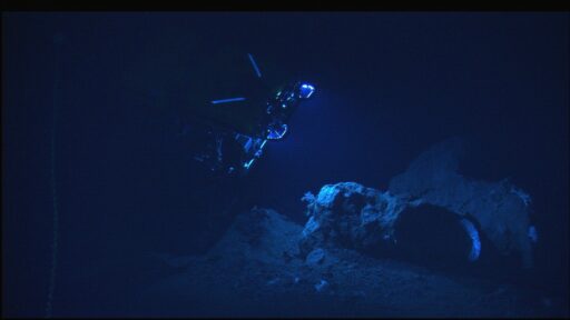
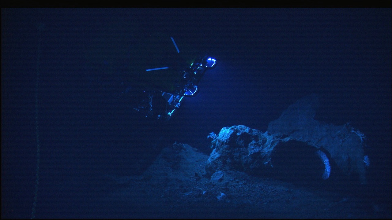
The recent work in Issyk-Kul did not begin with a spectacular single find, but with systematic mapping in just a few feet of water. Archaeologists operating between 3 and 13 feet below the surface along the lake’s northern margin say they have identified rectilinear foundations that form what look like streets, large public structures and a Muslim cemetery, all aligned in a coherent urban grid that stretches for hundreds of meters offshore. These shallow features, recorded by divers and sonar, underpin the claim that a substantial settlement now lies submerged near the present shoreline.
Researchers describe building walls made from stone blocks and compacted earth, some still standing several courses high, along with open areas that resemble courtyards or market spaces. The reported cemetery, with rows of grave markers oriented toward Mecca, suggests an organized Muslim community that had the resources to maintain a formal burial ground. Taken together, these elements support the idea of a planned city rather than a loose cluster of lakeside villages, and they align with historical references to urban centers that once ringed Issyk-Kul before the waterline crept inland.
Survey teams link the densest concentration of ruins to a city that they argue flourished in the early 1400s, then slipped beneath the lake after a combination of seismic activity and shoreline subsidence. In their interpretation, the settlement sat on low-lying alluvial plains that gradually sagged, allowing Issyk-Kul to inundate streets and buildings over several generations. While the precise sequence is still debated, the underwater topography and the depth of the ruins relative to the present shore support a scenario in which the lake advanced rather than the city abruptly collapsing into deep water.
Excavations on land near the submerged zone have recovered ceramics, metalwork and coins that specialists date to the late medieval period, strengthening the case for a thriving urban community at that time. Some finds show stylistic links to both Central Asian and Middle Eastern production centers, suggesting that the lakeside city participated in regional trade networks that connected the Tian Shan valleys to markets far beyond Kyrgyzstan.
Evidence that a “lost city” is more than legend
For decades, Issyk-Kul’s reputation rested on its altitude, its depth and its role as a Soviet-era resort, not on submerged ruins. That changed as divers began to report regular patterns of masonry in the shallows and as remote sensing revealed straight lines and right angles beneath the sediment. Underwater archaeologists now argue that the combination of structural remains, artifacts and burial grounds points to a lost medieval city of considerable size, rather than scattered farmsteads or isolated religious sites.
One research group working from inflatable boats and small barges has used side-scan sonar to trace what they describe as an urban street plan extending parallel to the modern shoreline. They report intersections, long linear features that resemble main roads and clusters of larger foundations that may represent civic or religious buildings. When divers followed up on these sonar targets, they encountered courses of stone and brick, sometimes covered by only a thin layer of silt, sometimes buried beneath thicker sediment fans that preserved wall outlines like negative casts.
Accounts from the project note that the underwater cemetery includes tombstones with Arabic inscriptions and decorative motifs associated with Islamic funerary art. If confirmed, these markers would anchor the site within the broader spread of Islam across Central Asia and help date the city’s final occupation phase. The presence of a formal graveyard also indicates a stable community that expected to remain in place, which fits poorly with the idea of a temporary caravan encampment and instead supports the vision of a permanent town.
Archaeologists working in these shallow zones along Issyk-Kul’s shore have stressed that their mapping remains preliminary, yet they already speak of a coherent urban footprint that they believe corresponds to a major early 1400s center tied to Silk Road trade. Their surveys, which document streets, public buildings and a Muslim cemetery in water as shallow as 3 feet, suggest that only a fraction of the drowned city has been systematically recorded so far, leaving a large part of the submerged landscape still unexplored.
Why a submerged Issyk-Kul city matters for Central Asian history
The emerging picture of a drowned medieval city at Issyk-Kul carries implications that reach far beyond a single Kyrgyz lake. If the interpretation holds, it would add a significant urban node to the historical map of Central Asia and help explain how goods, ideas and religious practices moved through the Tian Shan corridor between China, the Ferghana Valley and the Islamic heartlands to the west. The location on a navigable lake, framed by high passes, suggests a community that could mediate both overland caravans and regional water transport.
Historians have long debated how densely settled the Issyk-Kul basin was during the height of Silk Road trade. Written sources mention fortified towns and caravanserais, but the archaeological record has been fragmentary. A submerged city with clear urban planning, monumental buildings and a Muslim cemetery would demonstrate that at least one lakeside hub reached a level of complexity comparable to better known centers in Uzbekistan and Kazakhstan. That, in turn, would force a reassessment of population density, agricultural capacity and political organization in the region during the late medieval period.
The discovery also touches on religious history. The Muslim cemetery and Islamic inscriptions point to a community that had fully integrated into the Islamic world, yet Issyk-Kul also has associations with earlier Christian and Buddhist traditions. If future work uncovers layers that predate the Islamic occupation, the drowned city could preserve a rare stratified record of religious change on the Central Asian frontier, with material evidence for how local populations adopted and adapted new faiths over several centuries.
On a broader scale, the Issyk-Kul findings highlight how climate variability, tectonic activity and shifting water levels can erase entire cities from the visible landscape. The idea that a significant urban center could vanish beneath a mountain lake, leaving only faint traces in written chronicles, challenges assumptions about how complete the surface archaeological record really is. It also raises questions about other high-altitude basins across Eurasia that may conceal similar drowned settlements beneath their waters.
Competing theories, unanswered questions and scientific caution
Despite the excitement, specialists are careful to distinguish between what the evidence clearly shows and what remains speculative. The mapped walls, streets and cemetery speak to a substantial settlement, but its exact name, political affiliation and role in regional networks are still under discussion. Some researchers link the ruins to known cities from medieval texts, while others argue that the drowned site might represent a previously unrecorded town that never made it into surviving chronicles.
There is also debate over the mechanism that put the city under water. One camp emphasizes gradual shoreline migration, driven by tectonic subsidence and long-term changes in lake level. Under this model, residents would have had time to retreat upslope, abandoning buildings that were slowly flooded. Another group suggests that seismic events could have triggered more abrupt ground failure along the shore, leading to localized subsidence that dropped parts of the city below the waterline within a shorter time frame. Sediment cores and detailed bathymetric mapping will be needed to test these competing scenarios.