
Residents along Oak Creek Canyon were told to leave their homes as the Pocket Fire exploded in size near Sedona, sending smoke and embers over one of Arizona’s most iconic drives and forcing the shutdown of State Route 89A. What began as a remote wildfire in rugged terrain quickly became a fast-moving incident that tested evacuation systems, tourism-dependent businesses, and the limits of a canyon that has burned before.
What changed as the Pocket Fire advanced through Oak Creek Canyon
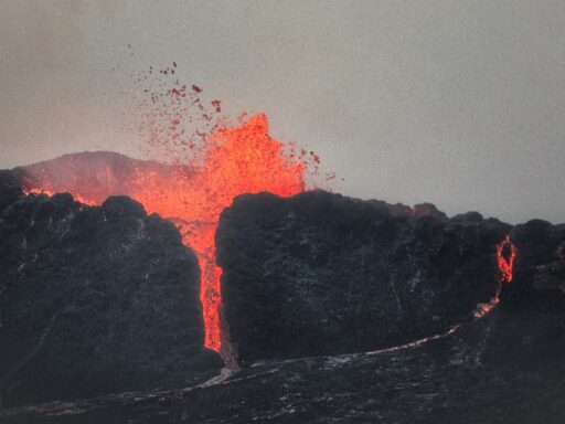
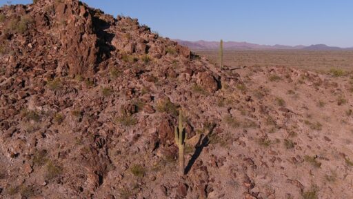
Fire managers watched the Pocket Fire grow from a remote blaze into a major incident that burned through steep, heavily forested country north of Sedona. Within days, the fire footprint expanded into the tens of thousands of acres, driven by dry fuels, hot temperatures, and shifting winds that pushed flames toward homes, campgrounds, and power infrastructure near Oak Creek Canyon. As the fire intensified, crews shifted from a mostly remote suppression effort to a full-scale operation that included structure protection and traffic control along the canyon corridor.
The growth in acreage translated directly into new evacuation zones. Authorities ordered residents and visitors out of parts of Oak Creek Canyon as the fire moved closer to cabins, lodges, and trailheads that line the narrow corridor. Those orders came with roadblocks on State Route 89A, the twisting highway that connects Sedona to Flagstaff through the canyon, after officials concluded that falling rocks, smoke, and the risk of sudden flare-ups made the route unsafe. For many canyon residents, the closure cut off the primary route to work, school, and medical care, forcing long detours via Interstate 17 or temporary stays in shelters.
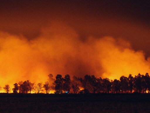
As the fire perimeter expanded, the incident also began to affect communities beyond the immediate canyon. Ash from the Pocket Fire drifted into Flagstaff, where residents reported particles on cars and patios and a persistent smell of smoke. That fallout signaled how intense the burn had become in the steep country between Sedona and the Mogollon Rim and underscored why crews prioritized holding lines near neighborhoods and critical infrastructure. Local officials urged people across northern Arizona to stay ready for changing conditions, including possible new evacuation notices if winds shifted or spot fires jumped control lines.
Tourism-heavy Sedona felt the shift quickly. Businesses that depend on scenic drives, hiking, and clear red-rock views saw cancellations as visitors confronted images of flames and heavy smoke in canyon country. The closure of State Route 89A cut off one of the most popular approaches into town, rerouting traffic and dampening the usual stream of day-trippers who drive the canyon for its tight curves and creek overlooks. For outfitters, hotels, and restaurants, the fire’s advance brought an abrupt mid-season shock layered on top of the safety concerns facing residents and workers.
On the fire lines, crews adapted tactics as the blaze moved from remote slopes into more developed areas. Incident commanders redirected resources toward structure protection in Oak Creek Canyon, deploying engines to defend homes and lodges while hand crews cut firelines in the rugged terrain above. Air tankers and helicopters dropped retardant and water along ridges and near the highway to slow the fire’s spread. Officials warned that gusty weekend winds would test those lines and could drive new runs if embers crossed into unburned fuel, a risk that kept residents on edge even after the first round of evacuations.
Why the Pocket Fire’s evacuations and highway closure matter now
The forced departures from Oak Creek Canyon and the shutdown of State Route 89A show how wildfire has become a direct threat to daily life in northern Arizona, not just a distant summer headline. The canyon is both a neighborhood and a gateway for millions of visitors each year, and the Pocket Fire revealed how quickly that dual identity can turn into a vulnerability. When flames approached cabins and trailheads, officials had to choose between keeping an economic lifeline open and protecting people from a dynamic fire environment in a narrow, steep-walled corridor.
For residents, the episode reinforced the reality that living in fire country now means staying packed and ready to leave on short notice. Many canyon homeowners had already experienced previous fires in the region and had defensible space projects underway, yet the Pocket Fire still forced them out with little warning once evacuation levels rose. The incident tested emergency alert systems, door-to-door notification, and the capacity of shelters in nearby communities that took in evacuees and their pets. It also exposed gaps for people who rely on State Route 89A for work or health care and had to navigate long, unfamiliar detours while worried about what the fire might do next.
From an environmental perspective, the fire’s spread through Oak Creek Canyon and adjacent forests raised fresh questions about forest management in one of Arizona’s most loved landscapes. The canyon’s mix of ponderosa pine, juniper, and riparian vegetation has been stressed by drought and past insect damage, leaving heavy fuel loads that can feed intense fire behavior. The Pocket Fire burned through areas that had seen limited recent treatment, and its rapid growth illustrated how quickly such fuels can carry flames upslope toward homes, power lines, and communication towers that serve Sedona and surrounding areas.
The closure of State Route 89A also had regional implications for transportation planning. The highway is more than a scenic drive; it is an alternate route between the Verde Valley and Flagstaff when Interstate 17 is congested or closed. With 89A shut down, drivers had fewer choices, and emergency managers had to account for longer response times for ambulances, fire engines, and law enforcement moving between communities. The incident renewed conversations about whether additional turnouts, fuel breaks, or hardened infrastructure are needed along the canyon to keep at least limited access open during future fires.
Economically, the Pocket Fire hit at a time when Sedona and nearby towns rely heavily on summer tourism revenue. Lodging operators reported cancellations from guests who did not want to vacation near an active wildfire or who were discouraged by the closure of the canyon drive. Outfitters who run Jeep tours, creek excursions, and hiking trips saw bookings fall as trailheads closed and smoke obscured views. For small businesses already balancing high housing costs and seasonal swings, a fire-driven downturn added another layer of uncertainty that will linger even after the flames are contained.
The broader significance extends to wildfire policy across Arizona. The Pocket Fire came during a season when state and federal agencies had already warned about elevated fire danger due to dry conditions. Its behavior near Oak Creek Canyon will likely shape future decisions about prescribed burning, thinning projects, and community preparedness in the Sedona area and beyond. The evacuations and highway closure provided a real-time stress test of how well agencies coordinate and how quickly residents respond when a fire moves from remote slopes into a busy, inhabited canyon.
What comes next for Oak Creek Canyon residents and Route 89A
In the short term, the priority for Oak Creek Canyon residents is returning home safely and assessing damage once officials determine that fire activity has calmed enough to lift evacuation orders. Utility crews will need to inspect power lines, communication cables, and roadside infrastructure along State Route 89A before traffic can resume, especially in stretches where fire burned close to the pavement or destabilized slopes above the road. Rockfall and downed trees will have to be cleared, and transportation officials will weigh whether to reopen the route in stages or keep it restricted while rehabilitation work continues.
For homeowners and businesses, the next phase will involve both cleanup and planning. Those who return to intact properties will still face smoke damage, ash, and the risk of post-fire flooding or debris flows once monsoon storms arrive. Many will revisit defensible space projects, looking at where vegetation or wood piles might need to be moved farther from structures. Insurance questions will surface for those who suffered direct damage or lost income during the closure, and local governments may explore disaster assistance or small business support to help the canyon corridor recover economically.