
A magnitude 5.6 earthquake struck off the coast near Trenggalek on the southern side of Java, rattling communities long accustomed to the risks of living along one of the world’s most active seismic belts. The moderate offshore shock was strong enough to be widely felt across parts of East Java, yet early reports suggested relatively limited structural damage compared with larger recent events in the region.
For residents, the jolt was a fresh reminder that Java’s densely populated districts sit close to powerful tectonic forces. For authorities, it added urgency to long-running efforts to strengthen buildings, refine warning systems, and keep evacuation routes usable before a stronger event puts the system to a more severe test.
How the Trenggalek quake fits into Java’s active seismic pattern
The Trenggalek earthquake, measured at magnitude 5.6, originated offshore near the southern coastline of East Java, where the Indo Australian Plate pushes beneath the Sunda Plate along the Java Trench. That subduction boundary is responsible for frequent moderate quakes and occasional major events that can be felt far inland. Although this latest shock was not among the largest in recent memory, its location near coastal communities raised immediate concerns about shaking intensity and the possibility of secondary hazards.
Earlier seismic activity in the same broader region has highlighted how variable the impact of similar-magnitude events can be. A recent magnitude 6.0 earthquake near Ponorogo in Kabupaten Ponorogo, Jawa Timur, demonstrated how an inland epicenter can transmit stronger shaking directly into built-up areas. In that case, the higher magnitude and shallower focus translated into more intense ground motion for communities close to the epicenter, even though the affected population and infrastructure profile were similar to those near Trenggalek.
By comparison, the Trenggalek event occurred offshore, which helped disperse some of the energy before it reached land. Residents in low-rise neighborhoods still reported swaying buildings and rattling windows, but the pattern of damage was more patchy. This contrast between two relatively close quakes, one offshore near Trenggalek and one inland near Ponorogo, illustrates how depth, distance, and local geology can matter as much as magnitude when it comes to real-world impact.
Seismologists monitoring Java’s southern margin have long warned that moderate events like these are part of a continuous release of tectonic stress along the plate boundary. Each quake provides new data on how the crust behaves and which segments of the fault system are most active. The Trenggalek shock, when combined with the Ponorogo sequence and other recent tremors, helps refine hazard maps that guide building codes and land-use planning across East Java.
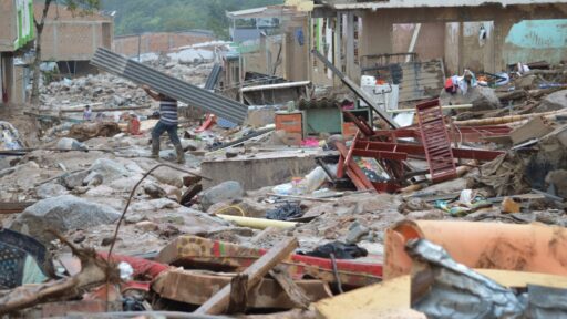
Immediate effects on communities and why the timing matters
The quake near Trenggalek struck at a time when many residents were at home, which helped limit exposure in offices, schools, and factories that can concentrate large numbers of people in vulnerable structures. Local disaster officials moved quickly to check key facilities such as hospitals, bridges, and main roads, prioritizing routes that connect coastal districts with larger inland cities. Early inspections focused on older masonry buildings and unreinforced shop houses, which have historically fared poorly in Java’s stronger earthquakes.
Although detailed damage tallies remained limited, the pattern of reports suggested that most structures experienced light to moderate shaking. Some residents evacuated briefly to open areas, following guidance drilled into communities after years of public education campaigns. The absence of widespread building collapse in the immediate aftermath pointed to a mix of luck, improved construction in newer districts, and the cushioning effect of the offshore epicenter.
The timing also intersected with broader concerns about disaster readiness across Indonesia’s main islands. Java’s population density means that even moderate quakes can affect large numbers of people, disrupt transport corridors, and test communication systems. Authorities have been trying to integrate seismic monitoring with local alert networks so that coastal residents receive faster guidance on whether to expect aftershocks or, in rarer cases, tsunami risk. While the Trenggalek event did not trigger a major tsunami alarm, its location along the southern coast ensured that emergency centers still ran through their protocols.
For many in East Java, memories remain fresh of more destructive events elsewhere on the island, where similar magnitudes caused far greater harm because of shallower depths or weaker buildings. Against that backdrop, the Trenggalek quake landed in a psychological context shaped by previous disasters, making communication from officials especially important. Clear statements about the absence of major damage and the low likelihood of significant secondary hazards helped calm residents who had rushed outside during the shaking.
Why a moderate offshore quake carries national significance
On paper, a magnitude 5.6 offshore event might seem minor compared with the catastrophic earthquakes that have struck Indonesia in the past. Its location near Trenggalek, on one of the country’s most economically important islands, however, gives it wider significance. Java concentrates a large share of Indonesia’s population, industry, and transport infrastructure. Any quake that tests the resilience of its coastal districts provides a live assessment of whether decades of policy efforts have translated into safer communities.
National planners have pushed for stricter enforcement of building codes in urban centers, but smaller coastal towns can lag behind due to limited budgets and technical capacity. The Trenggalek shock exposed that gap once again. While newer government offices and commercial buildings generally performed well, older housing clusters and informal settlements remained vulnerable. Engineers examining cracked walls and dislodged tiles will use those observations to argue for targeted retrofits, especially in schools and clinics that serve as emergency shelters.
The event also matters for Indonesia’s ongoing investment in early warning technology. The country has been expanding its network of seismometers and communication links, aiming to provide faster, more localized alerts. Each moderate quake offers a chance to test whether sensors detected the shaking in real time, whether alerts reached local disaster agencies promptly, and whether those agencies had clear protocols for public messaging. In that sense, the Trenggalek quake functioned as both a hazard and an unplanned system drill.
At a regional level, the quake reinforces the shared risk along the southern fringe of Java, where coastal regencies from Pacitan to Banyuwangi face similar tectonic exposure. Coordination among these districts on evacuation routes, shelter capacity, and mutual aid agreements can reduce the burden on any single area when a stronger event eventually arrives. The Trenggalek experience will likely feed into those conversations, especially if follow-up assessments reveal specific weaknesses in infrastructure or communication chains.
Next steps for preparedness, rebuilding confidence, and long term safety
In the short term, authorities in Trenggalek and neighboring regencies are expected to focus on three priorities. First, engineers will continue detailed inspections of public buildings, bridges, and key utilities, looking for hidden structural damage that might not be obvious immediately after the shaking. Any facilities that show significant cracking or foundation movement will need repair or temporary closure, even if they did not collapse.
Second, local disaster agencies are likely to review how residents responded. That includes assessing whether people knew where to gather safely, how long they stayed outside, and whether they received consistent information from village leaders and local media. These insights can shape future drills and public education campaigns, especially in schools and markets that often serve as community hubs.
Third, planners will revisit land-use maps and building regulations for coastal zones. The combination of seismic and potential tsunami risk argues for careful placement of new housing, industrial estates, and critical facilities. Where relocation is not feasible, priority will fall on strengthening existing structures, improving road access to higher ground, and ensuring that signage for evacuation routes is visible and maintained.
Over a longer horizon, the Trenggalek quake adds weight to calls for more equitable investment in disaster resilience across Java. Large cities tend to attract funding for sophisticated early warning systems and high-standard construction, while smaller coastal districts must stretch limited resources across many needs. By documenting how an offshore magnitude 5.6 event affected a mid-sized community, researchers and advocates can make a stronger case for channeling technical assistance and finance into places that often sit closest to the hazard.