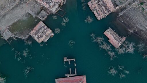
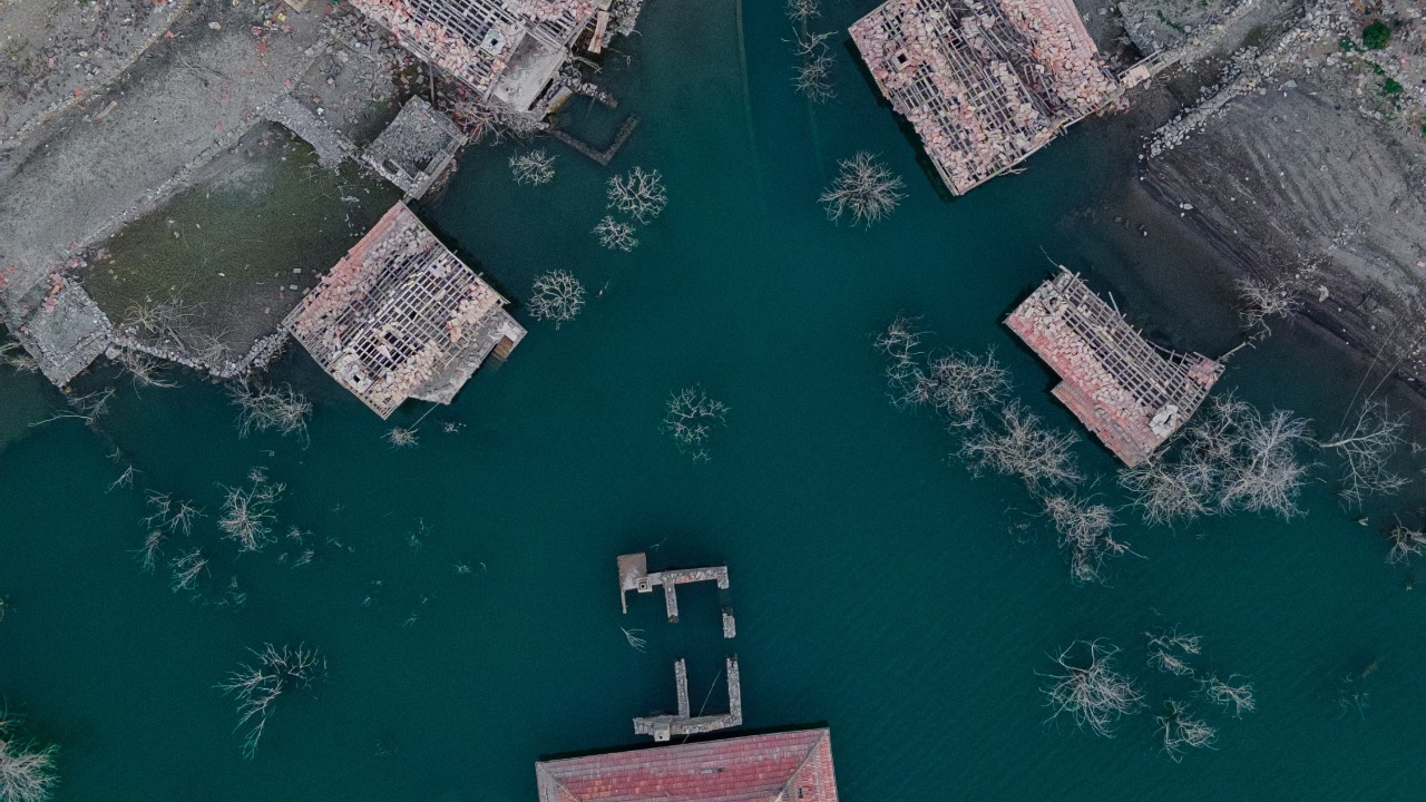

Archaeologists exploring the shallow waters of Lake Issyk-Kul in Kyrgyzstan have documented the remains of a substantial medieval settlement that once stood along an important section of the Silk Road.
The underwater site near the village of Toru-Aygyr contains fired-brick buildings, collapsed stone structures, wooden beams, pottery, a grain millstone and a large Muslim cemetery. Researchers believe the settlement was submerged after a powerful earthquake in the early 15th century, although they think its residents may already have abandoned it before the disaster.
Recent headlines have described the site as a drowned city “rising” from the lake and hailed it as the archaeological discovery of the century. The ruins are not physically emerging from the water, however. Divers are mapping and studying them beneath approximately one to four metres, or three to 13 feet, of water near the lake’s northwestern shore.
The Discovery Was Made During a 2025 Expedition
The major field investigation took place in fall 2025.
It brought together researchers from the Russian Geographical Society, the Institute of Archaeology of the Russian Academy of Sciences and the Institute of History, Archaeology and Ethnology of Kyrgyzstan’s National Academy of Sciences. The team investigated four underwater zones connected with the flooded Toru-Aygyr archaeological complex.
The expedition did not discover one perfectly preserved city centre with standing towers and complete streets. Instead, it documented multiple areas containing buildings, burial grounds, artifacts and evidence of organized settlement.
Together, those remains support the interpretation that the site was either a city or a large commercial community rather than an isolated collection of rural structures. Kyrgyz archaeologist Valery Kolchenko described it as a major settlement on an important Silk Road route.
Fired-Brick Buildings Were Found Underwater
At the first survey area, archaeologists recorded structures constructed from fired bricks.
One building contained part of a stone millstone used to grind grain into flour or meal. That find provides evidence of food processing and ordinary economic activity within the settlement.
The team also found an architectural decoration believed to have come from a public building. Researchers said the structure may once have been a mosque, bathhouse or madrasa, an Islamic educational institution. Its precise function has not yet been confirmed.
Nearby remains included collapsed stone walls and wooden beams. Samples of the wood were sent for dendrochronological and accelerator mass spectrometry dating to establish a more accurate construction timeline.
These discoveries indicate that Toru-Aygyr was a built environment with specialized structures rather than a temporary camp.
Divers Found a Large Muslim Cemetery
The second underwater zone contained a Muslim necropolis dating to approximately the 13th and 14th centuries.
The cemetery extends across an estimated area of 300 by 200 metres, or about 14.8 acres. Water movement is actively eroding parts of it, making documentation and preservation urgent.
The burials followed recognizable Islamic customs. The bodies were positioned so their faces were turned toward the qibla, the direction of the Kaaba in Mecca.
Researchers recovered the remains of one man and one woman for anthropological study. Analysis may reveal information about their age, health, diet, ancestry and lives within the settlement.
The cemetery is particularly valuable because it offers evidence of religious practice during a period of major cultural transition in Central Asia.
The Settlement Stood at a Religious Crossroads
The Issyk-Kul region was not associated with one continuous religious tradition.
During the medieval period, people in the area practiced forms of Tengrianism, Buddhism and Nestorian Christianity. Islam initially spread among ruling and commercial groups before becoming more widespread in the region during the 13th century under the influence of the Golden Horde.
The Muslim cemetery reflects that later period of Islamization.
Researchers also found three burials near another pottery-rich area that may belong to an earlier cemetery. This suggests that the site developed through several historical phases and may preserve evidence of changing religious and cultural practices.
The city may therefore help archaeologists understand not only Silk Road trade but also how belief systems changed as political power shifted across Central Asia.
A Large Ceramic Vessel Remains Embedded in the Lakebed
The third survey zone produced medieval ceramics and a large, mostly intact storage vessel known as a khum.
The vessel was too deeply embedded in the ground to remove safely during the 2025 expedition. Archaeologists plan to attempt its recovery during a future season.
Large ceramic containers were commonly used to store grain, water, oil or other goods. Laboratory examination of material inside or around the vessel could help determine how the settlement’s residents lived and what they produced or traded.
Pottery can also be used to date occupation layers and identify cultural connections with other communities along the Silk Road.
Underwater Drilling Is Reconstructing the City’s History
At the fourth zone, archaeologists examined rounded and rectangular structures in the western part of the complex.
They also conducted underwater drilling to collect samples from mud walls and buried soil layers. These samples may allow researchers to reconstruct different stages of the settlement’s growth, destruction and eventual submersion.
Underwater drones were used to record the ruins precisely and create a baseline for monitoring their future condition.
That is important because waves, sediment movement and changing water levels can expose objects during one season and bury or damage them during another.
The City May Have Been Lost in a 15th-Century Earthquake
Researchers believe a major earthquake struck the settlement at the beginning of the 15th century.
Kolchenko compared the disaster with Pompeii because a thriving settlement was effectively removed from the inhabited landscape by a sudden natural event. He also said the population appears to have left before the city was submerged, meaning the disaster may not have killed the residents in place.
The earthquake may have altered the shoreline or caused the land beneath the settlement to sink. Changes in the lake’s water level could then have completed the flooding process.
Central Asia is highly seismically active, and earthquakes have repeatedly reshaped mountain slopes, valleys and settlements throughout the region. The exact geological sequence at Toru-Aygyr still requires further study.
It Was Probably a Silk Road Trading Centre
The Silk Road was not a single road but a network of routes connecting China, Central Asia, the Middle East and Europe.
Settlements along those routes supplied travelers, processed agricultural goods and served as markets where merchants exchanged products, information and religious ideas.
The Toru-Aygyr site appears to have occupied a strategically important position within that network. Archaeologists believe it may also be identifiable in medieval Chinese sources, which researchers are now comparing with the physical evidence from the lake.
The grain mill, large storage vessels, decorated public building and extensive cemetery all support the interpretation of a permanent and economically active community.
Lake Issyk-Kul Is an Extraordinary Archaeological Setting
Lake Issyk-Kul lies high in Kyrgyzstan’s Tian Shan mountains.
UNESCO describes it as the world’s second-largest high-mountain lake. It stretches approximately 180 kilometres in length and 60 kilometres in width and reaches depths of up to around 700 metres. Its low salinity, depth and warm springs help prevent it from freezing completely during winter.
The newly investigated ruins lie near the shallow shore rather than at the lake’s deepest point.
Issyk-Kul is an enclosed lake without a natural river outlet, making its shoreline sensitive to long-term water-level changes. Settlements that were once located on dry land can become submerged as environmental and geological conditions change.
The official UNESCO Issyk-Kul Biosphere Reserve overview provides additional information about the lake’s geography and ecological importance.
This Is Not the First Evidence of Sunken Settlements
Stories about lost settlements beneath Issyk-Kul have circulated for generations, and earlier underwater discoveries had already shown that parts of the ancient shoreline were inhabited.
What makes the Toru-Aygyr investigation important is the scale, organization and quality of the evidence.
Researchers did not find only scattered pottery or an isolated wall. They documented multiple structural zones, public architecture, economic equipment, burial grounds and several chronological layers.
The discovery confirms that a significant medieval settlement once occupied the area now covered by the lake.
It also provides a research site where archaeology, geology, anthropology and historical records can be studied together.
Is It Really a “Lost City”?
The term “lost city” is understandable but should be used carefully.
The remains appear to belong to a substantial urban or commercial settlement, and researchers themselves describe the site as a city or large trading agglomeration.
However, excavation and dating are still underway. Archaeologists have not yet exposed the complete street plan, determined the settlement’s full population or conclusively identified every structure.
The romantic comparison with Atlantis is even less scientific. There is no suggestion that Toru-Aygyr was a mythical civilization or that it disappeared in one mysterious moment without historical context.
It was a real medieval settlement located in an earthquake-prone region whose landscape and lake level changed over time.
Is It the “Find of the Century”?
“Discovery of the century” is primarily a headline phrase used by news and popular-science outlets.
The expedition’s official report does not formally award that title to the site. It describes Toru-Aygyr as an important Silk Road settlement and emphasizes the value of the cemetery, architecture and environmental evidence.
Archaeological significance is also difficult to rank globally. The century has already produced major discoveries involving ancient DNA, submerged landscapes, lost cities and previously unknown structures.
Toru-Aygyr may nevertheless become one of Central Asia’s most important underwater archaeological sites because of its preservation, cultural setting and potential to clarify the region’s medieval history.
Why the Discovery Matters
Central Asian history is often reconstructed from the written records of neighboring empires.
An archaeological city beneath Issyk-Kul offers direct physical evidence of how people in the region lived, traded, worshipped and adapted to political change.
The cemetery may reveal how Islamic practices became established. The buildings can clarify local architecture and urban planning. Pottery, storage vessels and mill equipment may show how the community participated in regional commerce.
Sediment and soil samples could also reveal how a major earthquake and changing shoreline transformed the settlement.
This combination of cultural and environmental evidence makes the site much more valuable than a collection of visually dramatic underwater ruins.
The City Is Not Literally Rising
Descriptions of the settlement “rising from the lake” should not be taken literally.
The structures remain beneath shallow water, and archaeologists are using diving equipment, drones and underwater excavation techniques to study them.
There is no current announcement that the full settlement is becoming exposed because of a rapidly falling lake level.
The sense that the city is emerging comes from the growing amount of information being brought to public attention through mapping, artifact analysis and scientific reporting.
Its history is rising into view, even while its walls remain underwater.
More Research Is Planned
The expedition team intends to continue dating the wooden remains, analyzing human skeletons and examining the sediment samples.
Researchers also hope to recover the large ceramic vessel during a future field season and connect the archaeological evidence with Chinese and other medieval written sources.
Future surveys may reveal more of the city’s boundaries, road system and public buildings.
The underwater digital records will help scientists compare conditions over time and identify areas being damaged by erosion.
Full scientific publications are expected to provide more precise conclusions than the preliminary expedition announcements.
The Main Takeaway
Archaeologists have confirmed that a major medieval settlement once stood near Toru-Aygyr on the northwestern shore of Lake Issyk-Kul.
The site includes fired-brick buildings, a millstone, decorated architecture, wooden beams, pottery, earlier burials and an extensive 13th- to 14th-century Muslim cemetery.
Researchers believe the settlement served as an important Silk Road trading centre and was submerged following a powerful earthquake in the early 15th century.
Calling it a drowned city is reasonable. Saying it is physically rising from the lake is more poetic than literal, while “find of the century” remains a media judgment rather than an official archaeological conclusion.
The genuine story is still remarkable: beneath a few feet of water in one of the world’s great mountain lakes, archaeologists have found the remains of a complex community that connected trade, religion and daily life across medieval Central Asia.