The eastern Pacific hurricane season roared to life this year with its busiest opening stretch since 1985, rapidly spinning up storms off Mexico and testing coastal preparedness before summer even hit full stride. The flurry of named systems, clustered near heavily traveled resort corridors and shipping lanes, has turned what is usually a slow ramp-up into an early stress test for emergency managers, forecasters, and residents along the Mexican Pacific coast.
That historic pace is more than a meteorological footnote. It is reshaping how coastal communities think about the first half of the season, when many still expect a lull, and sharpening questions about how ocean conditions and long-term climate trends are stacking the odds for more active early seasons in the years ahead.
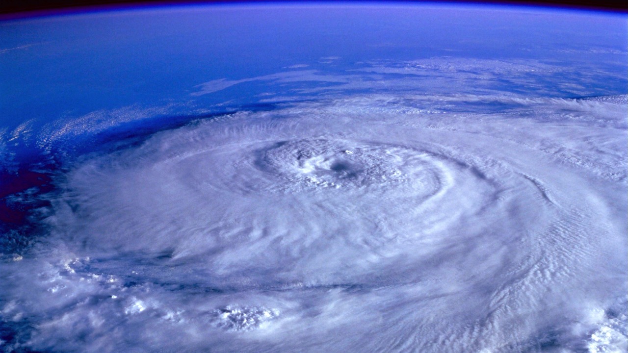
How the 2026 Pacific hurricane season broke from the usual script
In a typical year, the eastern Pacific basin starts quietly, with only one or two named storms forming far from land in May and early June. This season, by contrast, the basin quickly produced multiple organized systems off Mexico, enough to make it the busiest opening since 1985 and to draw attention to how unusual the pattern has become. Several early storms formed close to the Mexican coastline, tracking near popular destinations and fishing hubs that are more used to midseason threats than early ones.
Meteorologists point to a combination of warmer-than-average sea surface temperatures and favorable atmospheric patterns that reduced wind shear over the region. Warm water provides the fuel for tropical cyclones, while low shear allows thunderstorms to stack vertically and consolidate into a rotating core. When both align near the coast, storms can spin up rapidly and reach named status within a short distance of land, which is what happened with several of the early-season systems that clustered off Mexico.
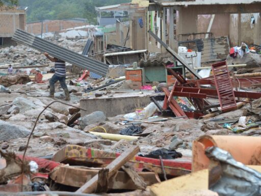
Tracks also broke from the norm. Instead of curving harmlessly out to sea, several storms hugged the coastline or moved on a parallel path that kept outer bands over land for days. That pattern brought repeated rounds of heavy rain to states such as Guerrero, Oaxaca, and Michoacán, even when the storm centers stayed offshore. In some communities, this meant flooding, landslides in steep terrain, and disrupted road and port operations long before the traditional peak in August and September.
Forecasters noted shorter lead times between tropical depressions forming and storms reaching tropical storm strength. When systems intensify quickly near land, emergency managers have fewer hours to issue warnings, close schools, or prepare shelters. The early-season storms highlighted that vulnerability, especially for smaller coastal towns that rely on limited communication networks and may not receive timely updates when storms strengthen overnight.
Why an explosive early season raises new stakes for Mexico and beyond
The rapid start to the season matters most for the people and infrastructure in the storms’ path. Mexico’s Pacific coast is lined with resort cities, ports, and fishing villages that depend on predictable weather windows to keep tourism and trade running. When named storms form in quick succession near the coast, hotels face repeated cancellations, ports must juggle closures, and small fishing operations lose days of income waiting for seas to calm.
For local governments, the early barrage has exposed gaps in preparedness. Many municipal emergency plans are built around the idea that the most intense activity arrives later in the season, when budgets, stockpiles, and staffing are geared up. This year’s pattern forced officials to activate shelters and evacuation protocols weeks earlier than usual, stretching resources and raising questions about whether seasonal planning needs to start sooner and last longer.
Public health and safety are also at stake. Repeated heavy rains can contaminate drinking water systems, trigger sewage overflows, and increase mosquito breeding, especially when drainage infrastructure is overwhelmed. Communities that experienced back-to-back storms saw prolonged power outages and road washouts, which complicated access to clinics and delayed deliveries of food and fuel. These compounding impacts show how a hyperactive early season can strain systems that are already under pressure from heat waves and other climate-related hazards.
Globally, the early surge in Pacific storms feeds into a broader conversation about climate signals in tropical cyclone behavior. Scientists caution against linking any single season directly to long-term warming, yet they track patterns such as warmer sea surface temperatures, higher ocean heat content, and shifts in large-scale circulation that can influence where and when storms form. When an early season aligns with those signals, it becomes a case study for how future decades might look if greenhouse gas emissions keep rising.
Insurance markets and supply chains are watching closely as well. Ports along the Mexican Pacific coast handle agricultural exports, manufactured goods, and fuel shipments that connect to North American and Asian trade routes. Early disruptions can ripple through shipping schedules and inventory planning, especially when storms force repeated port closures or rerouting. For insurers, a season that starts strong increases the probability of higher cumulative losses, even if no single storm reaches catastrophic intensity.
What the early storms reveal about forecasting and communication
The busiest start since 1985 has also served as a live test of forecasting tools and public communication. Satellite data, ocean buoys, and high-resolution models have improved significantly over the past few decades, giving meteorologists better insight into storm structure and potential tracks. Still, rapid intensification close to shore remains a difficult challenge, and the early storms exposed how quickly conditions can change in a matter of hours.
Forecast centers issued frequent updates and used cone graphics, wind probability maps, and rainfall forecasts to convey risk. Yet residents in some coastal areas reported confusion when storms shifted course or strengthened faster than expected. That experience has renewed calls for clearer messaging that emphasizes impacts such as rainfall and storm surge, rather than focusing only on wind categories. When a tropical storm can drop extreme rain totals over mountainous terrain, the risk of flash flooding and landslides may be as serious as that of stronger winds.
Social media has become a double-edged tool in this environment. On one hand, local officials and meteorological agencies can reach large audiences quickly with warnings and preparedness tips. On the other, misinformation and outdated graphics can circulate long after forecasts have changed. The early-season storms showed that communities with trusted local information channels, including radio and community networks, were better able to adapt as forecasts evolved.
For scientists, the season has generated a valuable dataset. Comparing the structure, intensity, and tracks of this year’s early storms with those from 1985 and other active years can help refine models and improve understanding of how environmental conditions interact with storm development. That research may eventually translate into more accurate lead times and better risk assessments for coastal infrastructure projects.
How Mexico and the Pacific coast can prepare for what comes next
The question now is whether the rest of the season will match the intensity of its opening chapter. Historical records show that a busy start does not guarantee an extreme finish, but it does raise the baseline risk. Warmer ocean waters and a favorable atmospheric setup can persist into late summer, keeping the door open for additional strong storms to form near Mexico and travel toward the central Pacific.
For coastal communities, the early wake-up call is prompting a reassessment of preparedness timelines. Local governments are reviewing evacuation routes, shelter capacity, and communication plans with an eye toward longer seasons and more frequent early threats. Some are exploring investments in flood-resilient infrastructure, such as elevated roads, improved drainage, and reinforced seawalls, to handle repeated storm impacts within a single year.
Residents and businesses along the coast are also rethinking their own timelines. Instead of waiting until midseason, many are now encouraged to complete home repairs, trim trees, and update emergency kits before the official start of the season. Hotels and tour operators are revisiting cancellation policies and contingency plans for guests, recognizing that early storms can disrupt key travel periods.