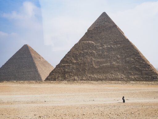

Fresh radar-based claims of vast structures hidden beneath the Giza pyramids have reignited one of archaeology’s most contentious debates: how much of ancient Egypt’s monumental landscape still lies unseen below the sand. Advocates say new satellite and ground-penetrating data reveal grid-like voids, possible tunnels, and what they describe as “underground cities” extending beyond the plateau. Skeptics counter that the evidence is being oversold, warning that misreading noisy scans risks turning routine anomalies into global headlines.
At stake is not only the story of how the pyramids were built, but also who gets to define credible discovery in an era when remote sensing tools can generate spectacular images long before any spade hits the ground.
Fresh radar interpretations and the claim of buried complexes
The latest wave of excitement centers on a satellite radar and ground-penetrating survey that, according to its proponents, outlines extensive sub-surface patterns under and around the Great Pyramid. The study’s authors argue that variations in radar reflectivity trace continuous, rectilinear features they interpret as man-made walls and chambers, stretching well beyond the known network of tomb shafts and workers’ quarters on the plateau. Their analysis, described in a satellite radar study, suggests multiple tiers of voids at different depths, which they say is consistent with a planned subterranean layout rather than random geology.
Supporters of the radar team have tied these patterns to long-circulating accounts of a “hidden city” beneath Giza. One Christian apologetics group, for example, has promoted earlier reports that described a grid of tunnels and chambers as an underground city that might date to the Old Kingdom or earlier. Those narratives draw on older, disputed testimonies from explorers who claimed to have entered extensive catacombs below the plateau, then link them with modern remote sensing anomalies to argue for a sprawling, cohesive complex.
The story escalated when a tabloid-style report framed newer radar readings as evidence for a “second hidden city” beneath Egypt’s pyramids. That account described scientists “doubling down” on the idea that one subterranean settlement lies under the Giza plateau while another extends toward nearby desert, both supposedly connected by long corridors. The report cited radar-bright alignments and clusters of voids as signs of streets and building foundations, presenting them as a second hidden city that mirrors the layout of the visible necropolis above.
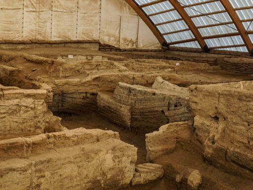
More traditional archaeological reporting paints a different picture. Coverage that focuses on documented digs highlights specific, excavated features such as unmarked shafts, small rock-cut rooms, and service tunnels discovered near the Great Pyramid. One such report details how archaeologists uncovered underground structures adjacent to known monuments, but describes them as modest, functional spaces rather than elements of a vast lost metropolis. These findings show that Giza still holds surprises below ground, yet they do not on their own support claims of an organized, city-scale network.
Fact-checkers have tried to separate what the scans actually show from what headlines suggest. A detailed review of viral posts about “newly discovered structures” beneath the pyramids concluded that several widely shared images were either miscaptioned or recycled from older projects. The analysis noted that some of the most dramatic visuals came from conceptual graphics rather than raw data, and it labeled the sweeping claim of a newly found underground city as unverified. The verdict stressed that while radar can hint at buried features, confirmation requires excavation, stratigraphy, and material analysis, none of which has yet demonstrated a hidden city beneath Giza.
Why contested radar “cities” matter for Egyptology and public trust
The tug-of-war over these radar scans touches on deeper questions about how archaeological knowledge is built and communicated. Remote sensing has transformed Egyptian fieldwork, allowing teams to map tombs, causeways, and settlement traces without disturbing the ground. When interpreted cautiously, techniques such as satellite radar and ground-penetrating radar can guide excavations toward promising targets, saving time and limiting damage to fragile contexts. Advocates of the Giza scans argue that the same tools that revealed buried pyramids and temples elsewhere in Egypt should be taken seriously when they highlight complex patterns beneath the plateau.
Yet Egyptology also has a long history of sensational claims that outpace evidence. Stories of secret chambers, alien engineers, and lost civilizations have repeatedly overshadowed painstaking, incremental discoveries. Critics of the “underground city” narrative warn that framing ambiguous radar anomalies as proof of a vast hidden world risks repeating that pattern. When later excavation fails to match the hype, public trust in both science and heritage authorities can erode.
The debate also reflects a tension between open data and interpretive restraint. Radar and satellite products are increasingly accessible, which allows independent researchers and enthusiasts to run their own analyses. That democratization can surface fresh ideas, but it also makes it easier for speculative interpretations to circulate without peer review. In the Giza case, some of the boldest claims have emerged in venues that do not follow standard archaeological publication practices, while more cautious assessments appear in specialist reports and low-key field updates.
There is a geopolitical and economic layer as well. Egypt’s tourism industry relies heavily on the pyramids, and any suggestion of dramatic new discoveries can influence visitor interest, funding priorities, and international partnerships. Officials must balance the appeal of bold announcements with the risk of endorsing findings that have not been tested in the ground. Overstating what radar can deliver might generate a short-term surge of attention, but it could also complicate future efforts to secure support for slower, methodical projects that lack headline-ready narratives.
How these claims are framed matters for education too. Teachers and museum curators often rely on high-profile discoveries to engage students and visitors. If the most visible stories about Giza are later walked back, audiences may become more skeptical of genuine breakthroughs, such as the identification of new tombs or the recovery of everyday objects that enrich understanding of ancient life. Clear communication about what radar data can and cannot prove is essential if the public is to distinguish between early-stage hypotheses and confirmed finds.
What researchers, officials, and the public should watch for next
The immediate test for the radar-based claims will be whether any targeted excavations follow. If Egyptian authorities grant permits for limited trenches or core samples in zones highlighted by the scans, those interventions could quickly clarify whether the anomalies represent natural fractures, ancient quarrying, or built spaces. Even a small number of well-placed shafts could transform the discussion from speculation to stratigraphic evidence.
Researchers are also likely to refine their methods. Future work may combine radar with other non-invasive tools such as electrical resistivity tomography, microgravity surveys, and high-resolution magnetometry. By layering multiple datasets over the same area, teams can cross-check anomalies and reduce the risk of misreading noise as architecture. Collaborations between remote sensing specialists and field archaeologists will be key, since understanding the geology and construction history of the plateau is essential for interpreting any signal beneath it.
For now, readers should expect continued circulation of dramatic claims about hidden cities and secret tunnels. Sensational narratives are unlikely to disappear, especially as social media rewards striking imagery and bold language. Fact-checking organizations and sober archaeological outlets will probably keep issuing clarifications when older stories resurface or when new radar graphics are shared without context. Reporting on nearby digs, such as excavations that uncovered unmarked structures near the Great Pyramid, shows how incremental, documented finds can still capture attention when presented clearly.
For Egypt’s antiquities authorities, the next phase will involve setting expectations. They may choose to encourage cautious use of remote sensing around Giza, while insisting that any claims of extensive underground complexes be backed by peer-reviewed analysis and controlled excavation. Transparent communication about what surveys are planned, what data will be released, and how decisions are made on digging permits could help defuse conspiracy theories that thrive on perceived secrecy.