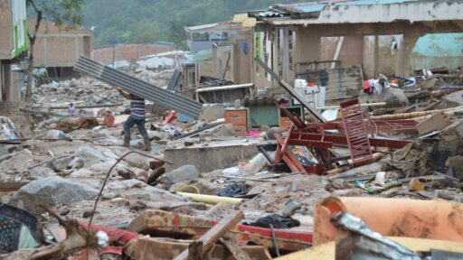
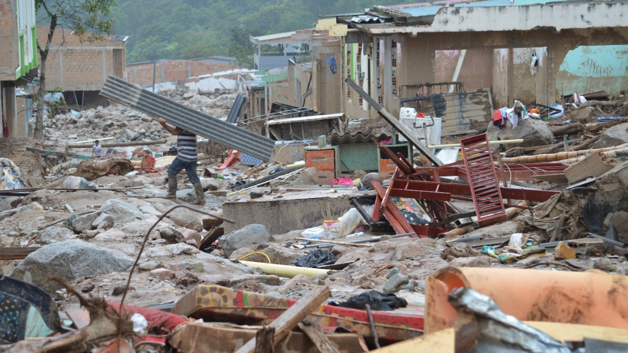

Colombia was shaken by one of its most powerful earthquakes in decades when a magnitude 7.4 earthquake struck western Colombia on August 10, 2026, damaging cities, collapsing buildings and leaving hundreds of people dead.
The U.S. Geological Survey located the earthquake about 5 kilometers south of San José del Palmar and measured its depth at roughly 110 kilometers. Despite originating unusually deep underground, the quake produced severe shaking and was felt across a huge part of Colombia and beyond its borders.
By August 16, Colombian authorities were reporting around 290 deaths, more than 140 people still missing and approximately 4,200 injured. Cali and Pereira were among the hardest-hit major cities.
The disaster was devastating on its own.
But geologically, it also delivered another powerful reminder of why countries around the Pacific Ocean live with some of the world’s greatest earthquake risks.
Colombia sits along the vast region commonly known as the Pacific Ring of Fire.
What Happened During the Colombia Earthquake?
The main earthquake struck at 12:34 UTC on August 10, according to the U.S. Geological Survey.
USGS assigned the event a Red PAGER alert, its highest category for potentially significant human and economic losses, while maximum shaking reached intensity VIII, described as severe.
The epicentral region was in western Colombia, but the shaking spread much farther because of the earthquake’s considerable magnitude and depth.
People reported feeling movement in Bogotá, Cali, Pereira, Manizales and other cities, while Reuters reported that tremors were detected as far away as Panama.
Buildings collapsed.
Hospitals were damaged.
Airports temporarily shut down.
Churches, homes, schools and apartment blocks suffered serious structural damage.
For many communities, the earthquake lasted only moments.
The recovery will take years.
Why Was a 7.4 Earthquake So Powerful?
Earthquake magnitude is logarithmic.
That means the difference between magnitude 6 and magnitude 7 is much greater than the numbers make it appear.
Reuters notes that a magnitude-7 earthquake releases more than 30 times the energy of a magnitude-6 earthquake.
A 7.4 quake therefore represents an enormous release of energy inside the Earth.
The shaking becomes particularly dangerous when that energy reaches populated areas containing vulnerable buildings.
An earthquake itself usually does not directly kill most victims.
Collapsing structures do.
Falling masonry does.
Landslides do.
Fires, broken infrastructure and secondary hazards do.
That is why two earthquakes with similar magnitudes can produce dramatically different death tolls.
Colombia’s Earthquake Was Surprisingly Deep
The August 10 earthquake occurred roughly 100 to 110 kilometers below the surface.
That is important.
Shallow earthquakes generally create more intense shaking immediately around the epicenter because their energy has less distance to travel before reaching the surface.
Deep earthquakes distribute energy across a wider region.
German Prieto, a geologist at Colombia’s National University, told Reuters that the depth of the Colombian event helped spread the shaking over a much broader area while also allowing some of the energy to dissipate before reaching the surface.
In other words, the depth was partly why so many people felt it.
It may also be one reason the disaster was not even worse.
What Caused the Earthquake?
Colombia lies in one of the most tectonically complicated parts of the planet.
The Nazca Plate lies beneath the Pacific Ocean west of South America.
The South American Plate carries most of the continent.
The Caribbean Plate also interacts with the region farther north.
These plates are constantly moving.
They do not slide smoothly past or beneath one another every second.
Instead, sections can become locked.
Stress builds.
Eventually the rocks can no longer contain that stress.
They suddenly move.
The stored energy travels outward as seismic waves.
Reuters reported that the Colombian earthquake involved tectonic movement associated with the Nazca Plate descending beneath the South American Plate.
This process is called subduction.
And subduction zones are responsible for some of the most powerful earthquakes on Earth.
This Is Where the Ring of Fire Comes In
The Pacific Ring of Fire is not literally a ring.
It is a huge horseshoe-shaped belt of tectonic boundaries surrounding much of the Pacific Ocean.
It stretches along the western coasts of North and South America, through Alaska and the Aleutian Islands, and across countries including Japan, the Philippines, Indonesia and New Zealand.
Much of this region contains subduction zones.
That is why it experiences so many powerful earthquakes and volcanic eruptions.
Colombia sits along the eastern edge of this broader Pacific tectonic system.
The country’s August earthquake was therefore not a random geological event occurring in an otherwise quiet place.
It happened in a country that regularly experiences earthquakes because of its plate boundaries.
The USGS continuously tracks major earthquakes around the world through its global monitoring network.
Explore current and recent earthquakes through the U.S. Geological Survey
The Ring of Fire Produces Some of History’s Largest Earthquakes
Many of the strongest earthquakes ever measured occurred along the Pacific margins.
Chile experienced the magnitude 9.5 Valdivia earthquake in 1960, the largest earthquake ever instrumentally recorded.
Japan’s magnitude 9.0 Tōhoku earthquake in 2011 produced a devastating tsunami and contributed to the Fukushima nuclear disaster.
Indonesia’s 2004 Sumatra-Andaman earthquake, which occurred within the wider Indo-Pacific tectonic system, triggered an Indian Ocean tsunami that killed more than 200,000 people.
Colombia itself experienced an enormous magnitude 8.8 earthquake near the Ecuadorian coast in 1906.
Reuters notes that the 1906 event released around 126 times more energy than the recent magnitude 7.4 quake.
That comparison puts the August disaster into perspective.
A magnitude 7.4 earthquake is enormous.
The planet is capable of producing much larger ones.
Why Colombia Is So Earthquake-Prone
Colombia’s location means earthquakes are an unavoidable part of its geology.
The country has several active faults.
The Andes run through its territory.
Oceanic and continental tectonic plates interact nearby.
Different regions therefore experience different types of seismic risk.
Western Colombia is particularly vulnerable because it sits closer to the subduction zone.
Mountainous terrain creates another problem.
Strong shaking can trigger landslides.
Roads can become blocked.
Remote communities can be cut off.
Rescue operations become more difficult.
Urban areas face a different danger.
Dense populations and older structures can turn intense shaking into mass casualties.
Buildings Make an Enormous Difference
Earthquake magnitude alone does not determine how deadly a disaster becomes.
Building quality matters enormously.
Japan experiences powerful earthquakes frequently but has invested heavily in structures designed to flex during shaking.
Chile has also strengthened earthquake-resistant construction after repeated major disasters.
Colombia began developing earthquake-resistant construction standards during the 1970s and adopted its first major building code after the destructive 1983 Popayán earthquake. Its current national code dates from 2010.
But a building code is only effective if structures actually comply with it.
Older buildings may predate modern standards.
Informal construction may not follow engineering rules.
Poor maintenance can weaken otherwise sound buildings.
And even properly designed structures have limits.
The August quake will likely provide engineers with valuable information about which designs performed well and which failed.
Cali and Pereira Suffered Heavy Damage
Much of the death toll became concentrated in major western cities.
By August 16, Reuters reported that more than two-thirds of confirmed deaths were in Cali and Pereira.
Apartment buildings collapsed.
Homes became unsafe.
Hospitals, churches and schools were damaged.
In some areas, emergency workers continued searching unstable piles of concrete for nearly a week after the earthquake.
The longer the search continued, the smaller the chances of finding survivors became.
Rescue operations also had to contend with aftershocks that could destabilize already weakened structures.
More Than 100 Aftershocks Followed
A large earthquake changes stresses within the surrounding crust.
The Earth does not simply return to normal immediately afterward.
Nearby faults and sections of the original rupture continue adjusting.
That produces aftershocks.
Reuters reported that Colombia had already recorded more than 100 aftershocks by the afternoon after the main earthquake.
Most aftershocks are smaller than the original quake.
They can still be dangerous.
A building that survived the first earthquake may have cracked walls, damaged columns or weakened foundations.
A smaller second tremor may then cause it to collapse.
That is why authorities frequently prevent people from returning immediately to heavily damaged structures.
Can Scientists Predict the Next Big Earthquake?
Not in the way people often imagine.
Scientists can identify earthquake-prone regions.
They can estimate probabilities.
They can map faults.
They can measure plate movement.
They can monitor small earthquakes and deformation.
But they cannot reliably say:
“A magnitude 7.4 earthquake will strike this exact city next Tuesday at 9:17 a.m.”
Prieto told Reuters that earthquakes cannot currently be predicted or prevented, but their effects can be reduced through preparation.
That distinction is crucial.
Earthquake science is extremely good at understanding where risk exists.
It is much less capable of knowing exactly when stored tectonic stress will finally be released.
Earthquake Early Warning Is Not Prediction
Some countries operate earthquake early-warning systems.
These systems do not predict earthquakes beforehand.
They detect an earthquake immediately after rupture begins.
Electronic signals travel much faster than destructive seismic waves.
That creates a short window—sometimes only seconds—during which warnings can be sent to locations farther from the epicenter.
Those few seconds can still be valuable.
Trains can slow.
Factory machinery can stop.
Hospital procedures can pause.
People can move away from windows or take cover.
But warning time near the epicenter may be extremely short or nonexistent.
That is why strong buildings remain the most important protection.
Why Didn’t the Colombia Quake Cause a Major Tsunami?
Powerful earthquakes near coastlines naturally raise concerns about tsunamis.
But not every large earthquake produces one.
The most destructive tsunamis generally occur when a shallow underwater earthquake causes major vertical displacement of the seafloor.
Colombia’s August 10 earthquake was deep beneath the continent rather than a shallow offshore rupture that dramatically lifted or dropped the seabed.
That substantially reduced the tsunami threat.
The 1906 Colombia-Ecuador earthquake was very different.
That offshore magnitude 8.8 event generated a destructive tsunami that killed hundreds.
Similar location does not necessarily mean similar consequences.
The rupture mechanism and depth matter enormously.
The Earthquake Came During a Difficult Period for the Region
Colombia’s disaster came only weeks after powerful earthquakes struck neighboring Venezuela.
Reuters reported that the Venezuelan earthquakes had killed thousands, making the Colombian event part of an unusually destructive period of regional seismic activity.
That does not necessarily mean the earthquakes were directly connected.
Large earthquakes occurring relatively close together often encourage speculation that one “triggered” another.
Sometimes seismic stress changes can influence nearby faults.
But earthquakes occurring along different fault systems may also simply happen within the same tectonically active region without a straightforward causal link.
The Ring of Fire contains enough active boundaries that clusters of major earthquakes can occur without representing one continuous rupture.
The Pacific Has Been Active Elsewhere Too
Only days after the Colombia earthquake, a magnitude 7.7 earthquake struck eastern Indonesia on August 15, causing another major disaster.
Japan also experienced notable seismic activity later in August.
These events do not mean the entire Ring of Fire is suddenly “waking up.”
The Ring of Fire is always tectonically active.
Thousands of earthquakes occur around the Pacific every year.
Most are small.
Occasionally, enough stress accumulates on a major fault to produce a destructive event.
A cluster of large earthquakes can feel unusual to people watching the news.
Geologically, active plate boundaries do not follow human calendars.
Preparedness Matters More Than Trying to Predict the Next One
The most useful lesson from Colombia is not to wonder where the next viral earthquake video will come from.
It is preparation.
Earthquake-prone cities can strengthen old buildings.
Governments can enforce modern construction codes.
Hospitals and bridges can be retrofitted.
Emergency services can practice disaster response.
Residents can secure heavy furniture.
Families can know safe places to shelter.
Emergency supplies can be prepared.
Communication plans can be established before networks fail.
These measures are less dramatic than earthquake prediction.
They save lives.
What Should You Do During Strong Shaking?
The widely recommended response indoors is simple:
Drop, Cover and Hold On.
Drop to your hands and knees so shaking does not knock you over.
Take cover beneath a sturdy desk or table if available.
Protect your head and neck.
Hold onto your shelter until the shaking stops.
Running outside during intense shaking can expose people to falling glass, bricks, signs and other debris.
After the earthquake, damaged buildings, broken gas lines, electrical hazards and aftershocks become the next concerns.
For official preparedness information, the USGS and emergency-management agencies provide detailed earthquake guidance.
Learn more about earthquake hazards and preparedness from the USGS
Colombia Now Faces a Long Reconstruction
The immediate rescue phase has gradually shifted toward recovery and rebuilding.
By August 16, around 290 people were confirmed dead, more than 140 remained missing and thousands had been injured.
Many survivors lost homes.
Schools and hospitals require repairs.
Businesses have been damaged.
Infrastructure needs inspection.
Authorities must also determine which buildings can safely be occupied and which need demolition.
Reconstruction after a major earthquake is not simply about replacing what fell.
It is also an opportunity to ask why particular structures failed.
Every collapsed building contains lessons engineers can use to make the next earthquake less deadly.
The Ring of Fire Is Powerful, but Disaster Is Not Inevitable
Colombia cannot move away from its tectonic boundaries.
Japan cannot.
Chile cannot.
Indonesia cannot.
California cannot.
Earthquakes will continue occurring around the Pacific because the plates beneath these countries continue moving.
But geological hazard and human disaster are not the same thing.
Countries cannot stop tectonic plates.
They can determine how buildings are constructed.
They can improve warning systems.
They can prepare rescue teams.
They can reinforce hospitals.
They can educate communities.
Colombia’s magnitude 7.4 earthquake was powerful enough to shake cities hundreds of kilometers apart and kill hundreds of people.
Yet its roughly 100-kilometer depth may have prevented an even more catastrophic outcome.
That is the uncomfortable reality of living around the Pacific Ring of Fire.
The forces below the surface are enormous.
They are permanent.
And they operate on timescales completely indifferent to cities, borders and human plans.
The question is therefore not whether places like Colombia will experience earthquakes again.
They will.
The real question is whether the lessons learned from August 10 make the country better prepared when the ground eventually begins moving again.
Read Reuters’ explanation of why the Colombia earthquake was so destructive